
Garmin Montana 710 Topo EU
 Installment calculator
4,9%
interest
from 13.59 € monthly
Installment calculator
4,9%
interest
from 13.59 € monthly
Garmin Montana 710 Topo EU
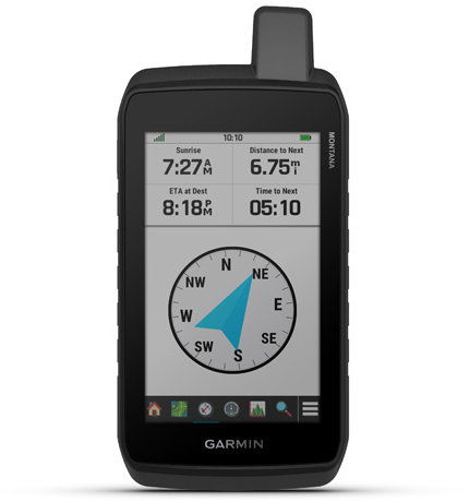
The Garmin Montana 710 offers maps with automatic route calculation for roads and trails. Advanced outdoor features are displayed on a durable 5-inch display that's perfect for navigating hiking, biking, kayaking, ATVing and many other sports. Access to GPS and Galileo satellite networks allows the Montana 710 to navigate in more challenging environments than when using GPS alone. In addition, the ABC sensors - Altimeter for altitude, Barometer for monitoring weather changes and Compass for three axes - help you navigate in the field. In addition, all sensors can be automatically or manually calibrated. Hunters and handlers will appreciate that Montana syncs with compatible Astro® or Alpha® series devices to help track hunting dogs in the field. The built-in WIKILOCK app feature offers easy downloads of hiking, biking and other trails shared by outdoor enthusiasts.

Key features of Garmin Montana 710 Topo EU GPS navigation
- Large 5″ sunlight readable touchscreen
- Precise navigation thanks to GPS and Galileo
- Built-in compass and barometric altimeter
- Pre-installed topographic maps of Europe
- BirdsEye satellite images directly on the device
- Support for Garmin Explore™ and Connect™ apps
- Battery life up to 24 hours in GPS mode and up to 440 hours in Expedition mode
- Waterproof rating IPX7
- Internal memory 32 GB
- USB-C interface
- Chemically toughened cover glass
Detailed TopoAcitve maps, satellite images and OutdoorMaps+
You can use the pre-installed topographic maps for navigation, that show the contours, altitude, the coast, Rivers, landmarks and other elements. There are also free high-resolution satellite images that you can download directly to your device via Wi-Fi®.You get access to a photorealistic view of the roads and surrounding terrain and can create waypoints based on prominent landmarks. In addition, you can download additional maps to the 32GB internal memory, such as City Navigator® for drivers or BlueChart® g3 nautical charts (sold separately). Or add an Outdoor Maps+ subscription (sold separately) for ongoing access to a wide range of premium map content with regular updates sent directly to your Garmin device via Wi-Fi.

Plan, navigate, view
The Garmin Montana 710 allows you to add additional maps with a microSD™ card slot (up to 32 GB) and also features a base map with detailed automatic road navigation. It offers BirdsEye support for storing satellite imagery directly to the device and works with maps containing detailed hydrographic features such as coastlines, rivers, lakes and wetlands. It makes it easy to find points of interest including parks, campsites, viewpoints and picnic spots. It also shows national parks, nature reserves and protected areas. Capacity of map segments is up to 15,000, capacity of route points 10,000, allows to store up to 250 routes (max. 250 points per route, with automatic navigation max. 50 points) and the route record has a capacity of up to 20,000 points and 250 saved routes in GPX format. It also supports Rinex recording and storage of up to 300 activities in FIT format.

Smart features and outdoor tools for every day
Navigation offers smart features for every day, including smart notifications on the handheld module, current weather and active weather, Garmin Messenger and Garmin Connect™ compatibility, VIRB® camera remote control and LiveTrack safety features. For outdoor recreation, use point-to-point navigation, TracBack® function, area calculation, fishing times, information about the sun and moon, support for Geocaching Live and user maps (500 tiles). There is also an image viewer and LED beacon light,that you'll appreciate when moving in the field or in emergency situations.

All-day battery life and a wide range of uses
In Expedition mode, the GPS function has an extremely low power consumption and the Montana can therefore follow a route for more than two weeks on a single charge. The internal lithium battery offers up to 24 hours of battery life in GPS mode and recharges with a standard USB-C® cable. With a wide range of compatible mounts (sold separately), you can use Montana navigation when travelling by ATV, boat, car, motorcycle, caravan or other vehicle.

Durable construction
Rugged and water-resistant navigation meets MIL-STD 810 standard for resistance to heat, shock, water and vibration. It features a 5-inch transflective WVGA touchscreen display with glove control and offers versatile mounting options depending on the activities you want to use it for (mounts sold separately). The display resolution is 480 × 800 pixels.


Garmin Explore™ app
Plan, check and sync your waypoints, routes and trails via the web and Garmin Explore. You can even see the activities you have completed in the field. Free Garmin Explore™ mobile app allows you to connect your navigation to your smartphone, get automatic software updates, store stored data in the cloud, plan trips, smart notifications and more. Plus, when you connect with the Garmin Explore™ app, you can get up-to-the-minute weather information so you know exactly what to expect on your adventure.
Package contents:
Montana® 710, high-capacity lithium battery, USB cable (USB-C to USB-C), documentation
Specifications
Navigation type
Hardware and Software
Battery life and memory
Equipment and features
Maps
Languages
Dimensions
Weight
Color and finish
Package contents
| Code: | SPTgarm0033 |
| Warranty: | 24 months |
| Links: | Producer's Website: |
| Manufacturer information |
Garmin Würzburg GmbH, Leightonstraße 7, 97074 Würzburg, Německo, www.garmin.com, [email protected] 
|